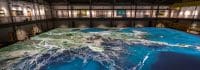
Projection Mapping at LSU Captures America’s Coastal Crisis
Christie projection mapping creates a movable, physical model at LSU Center for River Studies that helps educate about America’s coastal crisis.
Copy and paste this URL into your WordPress site to embed
Copy and paste this code into your site to embed